
California residents know that when it comes to precipitation, it is often a matter of feast or famine. Currently, Redding is experiencing the feast after a relatively dry spell. We wanted the drought to end but not, you know, all at once! At 79,000 cubic feet per second, releases from Keswick Dam are the highest they have been since the El Niño/La Niña cycle of 1997-98. Heavy rains have flooded valley towns and aging infrastructure is threatened. We are, however, lucky this isn’t 1862. In that year flooding was terrible. A United States Geological Survey paper confirms newspaper accounts that the Sacramento Valley was a 350-mile long, 20-30-mile wide lake!
Here at Turtle Bay, we are perfectly poised to watch the Sacramento River as it rises and falls with each controlled change in the release level and with every rainstorm. The plaza under the Sundial Bridge is underwater, but that has happened a few times since it was completed in 2004.

March 21, 2011
The Turtle Pond on the trail on the north side of river is currently part of the river and last week the river began flowing over the south trail for the first time since it was paved, filling the wetlands behind the museum.

February 13, 2017. The sign you can see in the 2011 photo is completely under water in the 2017 image.

The South Trail was impassable on February 14, 2017
Before Shasta Dam, this area flooded regularly. One of the dam’s primary purposes is to control those floods. The flood of 1906 washed out the old Freebridge, south of the current Cypress Street Bridge. It was rebuilt and then damaged again the following year. Floods in 1909 and 1913 affected the roads and rail lines. High river flows in 1915 threatened to take out the Diestelhorst Bridge while it was under construction.

Looking upstream in 1913.
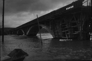
The Diestelhorst in February of 1915.
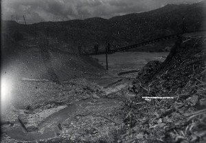
Rail line washout. This happened more than once before the dam was built.
While Shasta Dam was being built, Redding experienced its last major flood, the devastating Flood of 1940. On February 28, 1940 the city was cut off by the floodwaters. The storms that month caused the river to peak at more than 185,000 cubic feet per second at the dam site. In his 1997 article for the Covered Wagon, engineer Clair Hill cites a 189,000 cfs maximum flow. Hill also noted that he remembers driving south to Sacramento through water two feet deep on Highway 99. On February 29, 1940, the Oakland Tribune reported that the river was up to six miles wide in some places near Redding. I have heard anecdotal reports that the water crossed the buffer of floodplain farmland and reached the downtown Safeway on Cypress and Market streets.

A rare color slide of the gravel plant at Turtle Bay during the Flood of ‘40

A color slide of a Redding neighborhood during the Flood of ‘40
The east abutment of the old Free Bridge washed away, the abutments of North Market Street Bridge were damaged, and both ends of the Diestelhorst Bridge were under water, effectively cutting off vehicle traffic both north and east. The new rail trestle over the river was badly damaged as well.
In a 1994 Covered Wagon article, John Fitzpatrick recounts pushing a “borrowed” flat car of dairy products north across the trestle to replenish communities, such as Buckeye, that were completely cut off from the food supply. Sadly, that car was also used to ferry back the body of 19-year-old Irene Clement who had drowned in Salt Creek as the result of a car accident. Fitzpatrick reports that on the return trip, the trestle began to buckle as one of the supports gave way. They abandoned the flat car and carried Irene back to Redding.
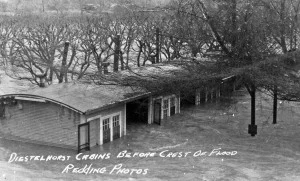
The Diestelhorst Auto Camp was destroyed in the Flood of ’40.
As we know from this February, Shasta Dam only controls river flooding; it does not prevent it entirely. Nor does it prevent downstream flooding from heavy rains or localized flash flooding. River flooding severe enough to make news across the state has occurred many times since 1940. For example, the San Bernardino County Sun reported a 70,000 cfs release in January of 1953 that flooded homes, ruined a new dance hall, and flooded the Riverview golf course. In February of 1970, the Red Bluff Daily News announced that 14 northern counties, including Shasta, were to receive Federal Disaster Relief funds as a result of heavy flooding. The El Niño of 1983 brought February flash floods and high releases, as reported in the Santa Cruz Sentinel.
What’s the moral of this story? Pay attention to the weather because Mother Nature bats cleanup and chin up, it could be 1862!